Monday, January 4, 2016

Seeds and Bones – 2 Educational Modules

Two new educational modules have been added to the Engaging the Piedmont: Transitions in Virginia Slavery website at http://web.utk.edu/~bheath2/Education/education-faunal.html
The data provided for the exercises were from two specialists’ reports in faunal remains (zooarchaeologists) and botanical remains (paleoethnobotanists). Both reports are available on the site’s resource section.

For the first module students are asked to carefully examine the data, and write a report that explains the findings. The data on the website can be sorted and filtered. Suggested questions include what types of plants/animal species were represented? Which were most common or rare?


The second module is a game. Students explore the map of the Wingo's site to discover foods that will build three different meals. Different areas of the map show different food types including: getting animals from trapping, gathering wild weeds, managing a garden and chickens, and accessing a store. Time is limited, and activity complicated by random events such as the weather and intrusive deer.

Both modules are supported by a Research Book providing images, text and the scientific and common names of species. We’ve also provided supporting teaching material for use in the classroom.

The modules still need a little tweaking, and we’re hoping for some helpful feedback. Please let us know what you think!

Monday, June 24, 2013

Privy, or pigeon house?


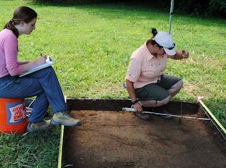
Hope-and-Jared-digging-ER338
For four days over fall break in 2012, a group of graduate students and volunteers came out to French’s Tavern. Among other activities, we excavated a 5’ x 5’ ft. unit to try to find additional post holes associated with the post-in-ground building we’d uncovered during the summer.  We succeeded in locating the three post holes; two of very similar size and fill and a third that looks very different. We didn’t have time to excavate them, but the two similar post holes are exactly in the right place to complete the circular arrangement of posts that we’d found earlier. Using straight walls to connect the posts would have resulted in an octagonal building, 7 ½ feet in diameter, with posts set at 3 ft. intervals. The wall facing due east was a bit longer at 3 ½ ft., and may be where the door was located.

Over the winter we processed the artifacts from the features that we had excavated to try to date the building. The post holes, which relate to the construction of the building, contained a variety of artifacts, including brick and daub, lime mortar, oyster shell, a lead shot, a straight pin, window glass, creamware, and pearlware. The post molds, which were filled when the building was no longer standing, contained similar artifacts, with the earliest date for construction, and destruction (known as the terminus post quem) set by undecorated fragments of pearlware. Pearlware was produced in England from 1779 to 1830. There are artifacts in the plow zone above the features that date later than pearlware. The fact that none of these items was deposited in the fill of the features suggests that the features were already filled in (and therefore the building was abandoned) before the later artifacts were thrown away. By this logic, our building probably stood sometime after the American Revolution and was torn down sometime before 1830.
 
Who was living on the property during this period? Thomas and Martha Jefferson sold the land in 1777 to their brother-in-law, Henry Skipwith. He might have built our octagonal building, but he already owned an extensive plantation, where he lived, in nearby Cumberland County (a place he called Hors du Monde). It is not clear why he would have built our structure. In 1798, Skipwith sold the portion of the property where our site is located to Francis Eppes Harris, Martha Jefferson’s cousin. Harris had grown up on land adjacent to Indian Camp and owned other property close by. Harris operated a store and a tavern on the property from 1798 to 1807. It seems likely that the construction of the octagonal building is associated with his ownership. 
  
The building we found stood about 100 ft. west of the west entrance of Harris’ store, which is annexed to the back of the tavern. What purpose did it serve? Historically, there are examples of small octagonal buildings serving as privies (outhouses) and as dovecotes or “pigeon houses”. Our building shows no evidence of a privy pit; however, waste may have been simply drained out into the yard, or been periodically collected from beneath the building, as was done at Poplar Forest. The archaeological footprint of the building is quite close in size to the surviving brick privies designed by Jefferson. Another possibility is that the building was a dovecote or “pigeon house” as they were known in the eighteenth century. Englishman Daniel Girton, in his 1785 book  The new and complete pigeon fancyer; or, modern treatise on domestic pigeons noted that:


“Pigeon houses of various forms and sizes, built of various materials, but mostly of wood, are to be seen in farmyards, the yards of inns and gentlemen’s courtyards, chiefly inhabited by pigeons kept for the table…”(Girton 1785:36-37).


He advised pigeon-keepers that round structures were preferable to square as they made it more difficult for rats to gain entry and made it easier for keepers to position a ladder when accessing nests, which were to be placed at least 4ft. from the ground. The size of the structure depended on the numbers of pigeons to be housed there.

How might we tell the difference, based on archaeological evidence, between the two building types, which had very different functions? Both would have generated significant amounts of waste, which would show up, on an undisturbed site, with high levels of phosphorus in the soil. However, the site continued to be used after the building was abandoned or torn down, so subsequent activities might have impacted soil chemistry. Artifacts specifically associated with privies or dovecotes would be few. Perhaps the best way of distinguishing between them will be to look at the broader landscape around them to see what other buildings, plantings, fencelines, or other features were associated with this building.

Thursday, June 13, 2013

Field School 2013


We started field work at French’s Tavern in mid-May, and on May 31st the field school students and volunteers arrived at the site. This year we have participants from the University of Tennessee, Knoxville;  Middle Tennessee State University; and Virginia Commonwealth University.

Testing Jeter's Field: Hope Smith-Christina Ramazani-Kirstie Durham
The first day of the field school was spent in the classroom and digging shovel test pits in a wooded area on the original Indian Camp property. We didn’t find any 18th-century artifacts, but students learned the basics of handling a shovel, screening, distinguishing soil changes, and recording information. Over the past two weeks, we’ve continued expanding the block excavation next to the historic tavern and store buildings, where we worked in 2011 and 2012, and testing an area we’ve called “Site C” further north along the field edge. Kathryn Gard, a rising junior in the Anthropology Department, received an undergraduate summer research award from the UTK Office of Research to conduct work at this site, which she’s doing in collaboration with project staff and students. We found a light scatter of 18th and early 19th-century artifacts there in 2010 and 2012, and decided to take a closer look this year to try to understand why historic artifacts are showing up in this area. 

Thursday, November 1, 2012

French’s Tavern - a pit and a round structure?


In 2011, our shovel test pits helped define a concentration of 18th- and 19th- century artifacts in a field west of the main house at French’s Tavern.  We dug a few larger units in plow zone in this area after one shovel test pit intruded into a feature which turned out to be a rectangular pit. Our shovel test pit revealed that the pit was quite shallow. Most of it had been cut away by later plowing, and many of the artifacts that were originally deposited in the pit were later mixed into the layer of plow zone above it. 
 We found British brown stoneware, colonoware, creamware, green bottle glass, window glass, nails (though most were too corroded to determine whether they were wrought or cut), as well as other, later, artifacts in plow zone above and adjacent to the pit.

 Their presence persuaded us to revisit this part of the site in 2012.  Our main objective was to explore the pit feature with these questions in mind: what artifacts did it contain? when was it filled it? what was it used for? We also hoped to find associated features that would help us understand why the pit and the concentration of artifacts above it in plow zone were there.  We laid in several 5’ x 5’ ft. units to expand on what we dug last summer and then unbackfilled the 2011 excavation units.

By the end of the summer, we had found eight post holes (with molds) and four smaller post molds beneath plow zone. Seven of the holes appear to be related in time and function as they are the same shape, the same depth, and contain similar fill. One is very different in size, shape, and fill and appears to be related to the pit. One of the group of seven postholes cut into the pit, which means that it was originally dug after the pit was filled in, ie. it is evidence of more recent activity. Once we excavated the intrusive posthole, the pit was ready for excavation. 

After mapping, recording soil colors with a Munsell soil color book, and photographing our pit, we were ready to excavate it.  We bisected it using an east-to-west line in order to preserve and map the profile.  Each deposit was given its own provenience in order to keep the soil and artifacts separated by context.  We collected soil samples and flotation samples from every layer. The lenses (very thin layers of sediment) filling in the feature consisted of mottled soil and ash. Back at the lab, we discovered that the pit also contained  small pieces of daub (clay used for chinking).  While there may be tiny artifacts in the flotation samples, the only artifact we saw while excavating the pit was a nearly perfectly preserved annealed, or burned, wrought nail. 

The pit was probably located underneath a building, so we laid in and dug a few additional 5’ x 5’ ft. units to try and find that building. One nearby posthole and mold seemed to be filled with the same ashy grey fill as our pit, but we haven’t yet found any other associated features.

Although the pit was shallow and did not contain any tightly datable artifacts, we can still make a few observations.  First, the pit is oriented along an east-west axis, the same orientation as the buildings on the French’s Tavern property and as Buckingham Road, the historic main road located 300 feet south of the pit.  This accommodates our modern sense of aesthetics but also says something about historic building orientation and order on the landscape when it was made.  Second, our one wrought nail suggests that the pit is old, although how old, we cannot say for certain.  Third, based on the pit’s fill and our annealed nail, we can say that some type of burning episode took place.  The ashy fill of one posthole and mold also suggests that this feature is related to the pit, though without finding additional features, it is hard to say this for certain. Fourth, the presence of the later postholes, and the mix of later-dating artifacts, indicate that the site continued to be used after the pit was filled and abandoned.

So what’s next? We’re now working on sorting the flotation samples in the lab to look for small artifacts. So far we’ve found tiny pieces of burned bone and some eggshell. The botanical remains recovered from the samples will be sent to Dr. Heather Trigg’s lab at UMass Boston to be analyzed. We’ll also catalogue the artifacts in plow zone and from the adjacent post holes to look at the time span represented at this portion of the site and to try to date the post holes (knowing that the pit is earlier than all but one of them). Finally, we’ll map the location of the earliest artifacts within our block of excavations to see if they concentrate around the pit, supporting the idea that they were originally deposited within it but were later moved by plowing. All of this work needs to be accomplished before we can write a site report.

Tuesday, October 16, 2012

2012 field school at French’s Tavern


Site A overall with Crystal facing west

We just finished up the 2012 field school at French’s Tavern at the larger Indian Camp site. The purpose of the field work was to locate a quartering site dating from 1730-1777, the period of ownership of Francis Eppes, then John Wayles, and then Thomas Jefferson.

44PO158 covers an area of about 85 ft. x 125 ft. that is located at a field edge and extends into the adjacent forest. This field season, we laid out 10 5 ft. x 5 ft. units along the field edge in two rows in a checkerboard pattern in hopes of locating features associated with a possible slave quarter.

In the far southwest unit we found a large feature extending out of the northwest corner of the unit. We opened up another unit along the northern wall and the feature continued into that unit. It appeared to form to corner of a larger square or rectangle. We mapped the portion of the feature that was exposed and cored it with a small diameter coring tool. The soil contained within the core was uniformly silty from top to bottom, indicating that the feature contains a single layer of fill that probably represents sediment deposited from heavy rain. The core results suggest that the feature may be a tree-fall or other natural depression.

Katherine and Lauren mapping at Site A
In the other excavation units, we have found many artifacts that could relate to the target time period, but are not precisely dateable. For example, we’ve found many brick fragments, pieces of charcoal, fragments of dark green wine bottle glass, and hand wrought nails or fragments. We have also found sizeable pieces of iron that we have not yet identified.

The ceramics from the site are more dateable. Two types were made and used within our period of interest: English brown stoneware and creamware. The greatest concentration of these ceramics is on the eastern side of the northern line of units, closest to the forest edge. Fragments of Chinese porcelain may also date to this period, or may be later. Pearlware sherds, which date after 1780, have also been found at the site.

Large feature at 44PO158
A quick look at the spatial distribution of these artifacts may indicate that we are excavating at the edge of a site located slightly farther to the north, in the woods. Due to plowing, drainage and erosion, some of the artifacts may have moved down slope from the east, west, or south due to the sloping landscape of the site.
 
 Further work relating to the site will include analyzing artifacts and samples in the lab. 

Written by: Kathryn Gard 

Wednesday, October 3, 2012

Geophysics at Indian Camp


Gradiometry: Stephen and Crystal with gradiometer
In early June, Dr. Gerald Schroedl and Stephen Yerka came to explore the French’s Tavern subsite of Indian Camp with noninvasive surveying equipment.  Once the 20 meter grids had been shot in with the total station, I was able to assist during the process of surveying Site B with a gradiometer. Because the gradiometer functions by measuring changes in the earth’s magnetic field, Stephencould not wear any metal while operating it. We also had to remove the nails from the corners of the excavation units or the instrument would have registered them and the readings would have been essentially useless.

In order to take systematic readings across the grid, ropes were laid out and one had to be moved at intervals as a guideline for each transect—meaning that Dr. Schroedl moved one end of the rope and staked it into the ground, and I moved the other end the same distance. Then Stephen walked along the line (rope) at a pace of one meter per beep of the metronome on the gradiometer, and took a reading at each beep.

gradiometry: Stephen and Aaron with gradiometer
The readings taken by the gradiometer were then entered into a computer program by Stephen, where he could map the data. The magnetic anomalies were displayed on the map and could be clarified by “despiking,” which edits out high magnetic readings that would otherwise obscure the less obvious, but potentially meaningful, magnetic disturbances within the grid.

Rachel pulling ropes
Once the data are properly processed, gradiometry can provide useful information about a site and help direct decisions about where next to excavate.

Blog written by:

Rachel Guy